
Most of Skellig Michael island in Ireland, except for the lighthouse area, is owned by the state on behalf of the Irish people. It is a National Monument and in 1996 the entire island was inscribed on the UNESCO World Heritage List. A program of conservation commenced in 1978, directed by Grellan D. Rourke, Office of Public Works, and the extent of this has largely determined the scope of archaeological work undertaken on the island. It was deemed inappropriate to carry out any major excavations within the monastery itself given that the largely intact nature of this area does not necessitate it. The aim was to preserve the extant buildings and structures on the site and to avoid disturbing early medieval archaeological layers.
Essential conservation measures, however, did provide some opportunities for archaeological investigations here and at other points in the island, including on the South Peak. The archaeological excavations were principally conducted by Edward Bourke, Alan R. Hayden and Ann Lynch, National Monuments Service. All this work, which was often carried out under challenging and difficult circumstances, has provided much valuable information about Skellig Michael and a greater understanding of its significance during the early medieval period. This chapter provides an overview of the archaeology of the island taking into account the results of these excavations.
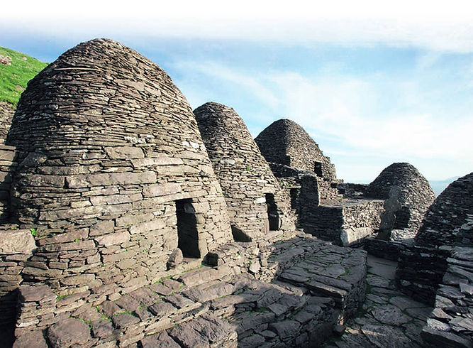
Mortared church in Skellig Michael island with seven clochauns
Most of Skellig Michael, except for the lighthouse area, is owned by the state on behalf of the Irish people. It is a National Monument and in 1996 the entire island was inscribed on the UNESCO World Heritage List. A programme of conservation commenced in 1978, directed by Grellan D. Rourke, Office of Public Works, and the extent of this has largely determined the scope of archaeological work undertaken on the island. It was deemed inappropriate to carry out any major excavations within the monastery itself given that the largely intact nature of this area does not necessitate it. The aim was to preserve the extant buildings and structures on the site and to avoid disturbing early medieval archaeological layers. Essential conservation measures, however, did provide some opportunities for archaeological investigations here and at other points in the island, including on the South Peak. The archaeological excavations were principally conducted by Edward Bourke, Alan R. Hayden and Ann Lynch, National Monuments Service. All this work, which was often carried out under challenging and difficult circumstances, has provided much valuable information about Skellig Michael and a greater understanding of its significance during the early medieval period. This chapter provides an overview of the archaeology of the island taking into account the results of these excavations.
Flights of steps
The peoples of Corcu Duibne were familiar with the association of high places with ritual, for this kingdom had three sacred mountains: Brandon, on the Dingle Peninsula, takes its name from St Brendan the Navigator, while Knocknadobar and Drung, on the Iveragh Peninsula, are associated, respectively, with St Fursa and St Fíonán. Each of these mountains was a focus for devotion and pilgrimage. In light of this, and given the kingdom’s profusion of island church sites, it is not surprising that at some stage during the early medieval period a remarkable monastery was founded on the Great Skellig, which combines these two distinctly numinous landforms: an isolated and challenging mountain peak that rises dramatically out of the Atlantic some 12km from the Iveragh mainland.
What is extraordinary, however, is that this achievement was then crowned by the establishment of an exceptional hermitage that clings precipitously to narrow ledges on the island’s South Peak. To establish their hold on the island so that plans for a monastery could become a reality, the early monks had to construct a safe route to the top of the island from one of the few landing places. This was no easy task, given the challenges of the very steep slopes and the dangers posed by the light vegetation, especially when it is wet. Presumably, there was initially only one route established, and this probably commenced at Blind Man’s Cove, normally the most sheltered of the landing places, from where it ascended the very steep slopes of the Skellig Syncline. However, recently a route has been discovered that appears to lead up from some point at the north-eastern corner of the island towards the monastery. It features masonry and rock-cut steps in places and may, perhaps, be earlier than the East Steps.
There are three different landing places on the island, usable depending on the prevailing weather and sea conditions, and it was from these that eventually permanent routes to the top were built. These routes now survive as long dramatic flights of hundreds of drystone masonry steps ascending to Christ’s Saddle and the monastery. They are mostly formed of single or paired flags supported on a low foundation of coursed stone, though those at sea level are cut into the bare rock. In some places the steps are initially rock-cut, then formed by flags set on a foundation of coursed stone. In other places on the ascent there are rock-cut steps that run alongside stretches of masonry steps, which are presumably later.
It seems the monks created their initial routes to the top of the island in a cautious exploratory manner and it may have been decades before the long flights of continuous steps, that are now such a distinguishing characteristic of Skellig Michael, became a feature of the island.
It is important to appreciate how imposing and unique these long flights of steps must have appeared to the early medieval people who saw and used them. Nothing remotely like them survives in Ireland’s mountain pilgrimage sites or at any of the early church sites that are found on mountain slopes along the west coast. On Skellig Michael they were, at one level, simply part of the basic infrastructure that enabled a monastery to be established on what one writer called ‘the most fantastic and impossible rock in the world’, but at another they were exceptional features, in both architectural and landscape terms, that served as an upward avenue to a unique monastery.
They must have been frequently described in contemporary wonder tales about the island. Later, when the monastery was dedicated to Michael the Archangel, the saint of high places, the steps presumably assumed even greater purpose and prestige.
Terraces
The flights of steps, like the mainland food-producers and the hide-covered boats that maintained communication with Skellig Michael, formed foundational elements of the monastery’s infrastructure. Another such element was the impressive sets of continuous drystone retaining walls that were constructed on the sides of the steeply sloping plateau on the east peak of the island. The maintenance of these walls, as with the flights of steps, must have been a routine task for the monastery. Their construction allowed for the levelling of areas on the steep slopes of the plateau, in places by up to 2-3m, in order to develop several terraces on which to build the monastery. It has been observed, fittingly, that ‘no other monastery in Ireland was built on such difficult terrain’.
![Fig. 1 Aerial view of the monastery on Skellig Michael. It is located on terraces retained by continuous drystone retaining walls that were constructed on the steeply sloping plateau on the east peak of the island. The upper terraces contained the monastic cells and churches, while the lower ones, known as the ‘monks’ gardens’, may have served as sheltered areas in which to grow crops. The development of the monastery on these terraces evolved in stages over several hundreds of years, and only its final phases are visible today. [Source: © Photographic Archive, National Monuments Service]](https://static.wixstatic.com/media/54ab98_bdb26630db3042acbb1df5c15927766e~mv2.png/v1/fill/w_80,h_58,al_c,q_85,usm_0.66_1.00_0.01,blur_2,enc_auto/54ab98_bdb26630db3042acbb1df5c15927766e~mv2.png)
![Fig. 2 Aerial view of a lengthy section of the East Steps, ascending to the monastery from Blind Man’s Cove. Several flights of steps formed an important part of the foundational elements of the monastery’s infrastructure. There are three different landing places on the island, usable depending on the prevailing weather and sea conditions, and it was from these that eventually permanent routes to the top were built. These routes now survive as long dramatic flights of hundreds of drystone masonry steps. [Source: © Photographic Archive, National Monuments Service]](https://static.wixstatic.com/media/54ab98_2290cb2d77044de8b112abe7d0e94420~mv2.png/v1/fill/w_50,h_80,al_c,q_85,usm_0.66_1.00_0.01,blur_2,enc_auto/54ab98_2290cb2d77044de8b112abe7d0e94420~mv2.png)
The development of the monastery on these terraces evolved in stages, and only the final phases are visible today. The main terrace, on which the churches and other monastic buildings now stand, was carefully paved and overlooks two further terraces, referred to as the ‘monks’ gardens’ or ‘garden terraces’.
A short distance away from the main terrace was a much smaller one, likewise paved, which also contained an oratory. The terrace revetment walls, which have been described as ‘an essential element of the monastery’s conception’, were constructed with forethought and great skill over a long period. They were designed to withstand the great pressures they came under from the retained material behind, and even though sections of them sometimes failed and collapsed, excavation has shown that these were then rebuilt.
The most impressive section of the revetment wall, at the small oratory terrace, is also one of the few stretches of original walling that has not been significantly altered since its construction; it stands on steeply sloping ground and is, remarkably, up to 5m in height.
Early medieval visitors to Skellig Michael must have been greatly impressed by the construction of the monastery, with its terraces and retaining walls. Those from Corcu Duibne would have, perhaps, been familiar with the terraced layout of elements of some church sites, such as Caherbarnagh, Killabuonia and Loher, on the Iveragh Peninsula, but may also have appreciated that work at these sites was essentially no more than a straightforward modification of slopes. On Skellig Michael, on the other hand, it may have seemed that level building spaces had been created outwards from the sides of a mountain peak, in stone, in an effort to impose structure on the island. They probably recognised that this work involved astute planning, careful quarrying and a great deal of skilled labour.
The scale of this achievement, particularly in relation to the length and height of some sections of revetment, must have been recognised as unique. While similar types of work may have been seen on mainland Corcu Duibne, for instance in the south side of the stone enclosure at Kildreelig, where the revetment wall rises to almost a height of 3m, such examples are not generally on the same scale of accomplishment as is evident on Skellig Michael.
![Fig. 3 Aerial view of the small oratory terrace. Located a short distance away from the main terrace, this smaller paved terrace contains a drystone oratory. The terrace revetment wall, standing up to 5m in height, is designed to withstand the great thrust from the retained material behind. It is one of the few stretches of revetment walling on Skellig Michael that has not been significantly altered since its construction in the ninth or tenth century. [Source: © Photographic Archive, National Monuments Service]](https://static.wixstatic.com/media/54ab98_844afdb9136b43a8b0a9303fd8490bd5~mv2.png/v1/fill/w_80,h_57,al_c,q_85,usm_0.66_1.00_0.01,blur_2,enc_auto/54ab98_844afdb9136b43a8b0a9303fd8490bd5~mv2.png)
The construction of the flights of steps and of the monastic terraces, which almost certainly took place in phases, represents the foundational work on the monastery in overall terms. But many questions remain about this and the subsequent building phases. Who did this work? Was it the early monks, or was it professional quarrymen and specialised drystone builders? Or was it a combined team? Was there an initial phase when a sod-built oratory and cells were in use, such as those excavated at the monastery at Illaunloughan, or was the monastery built in stone ab initio? Was there a masterplan for the building of the monastery, or did plans simply evolve over successive generations? How much work was involved? How much time passed before the first church was finished and the first cells occupied, when the site could be justly regarded as a monastery? Was the work carried out only in summertime, when the island is more accessible, or could it have continued to progress throughout the year? How were the workers supplied with food? Where did they sleep? If there were professional masons involved, who endowed them? Regrettably, it is impossible to answer most, if not all, of these questions, though the results of the archaeological investigations provide some information that is useful in addressing them.
It does seem likely that professional builders and masons were involved to some degree in the undertakings on Skellig Michael. The construction of revetment walls of this type requires an experienced approach, as does specialised quarrying and the formation of lofty flights of drystone steps. Even if nothing quite like the works on Skellig Michael were ever attempted on mainland Corcu Duibne, it does seem probable that the fundamental building skills were available within this kingdom. Certainly, by the eighth to ninth centuries drystone masons were building some of the many fine cahers, or stone forts, that survive on the Dingle and Iveragh peninsulas. Radiocarbon dating has shown that the very impressive site at Cahergal, close to Valentia Harbour, for instance, was constructed between the mid-seventh and mid-ninth centuries. A small number of these stone forts are exceptional constructions, such as the large example at Loher, while others display noteworthy and distinctive architectural features, such as the remarkable arrangement of steps, inset landings and terraces on the inner wall face of Cahergal: indeed, this site has been described recently as ‘undoubtedly one of the finest examples of a stone ringfort or cashel in Ireland’. Some of these stone forts were the centres of local kingdoms, and it seems very probable that their kings were involved in some way in supporting the foundation of the monastery on Skellig Michael. The dominant kingship in Corcu Duibne for much of this period was Áes Irruis Deiscirt, in western Iveragh, the dynasty from which the Ua Fáilbe (Falvey) and Ua Chongaile (O’Connell) lineages descend, and this probably took the lead in providing patronage for the island monastery. It already had experience in investing in another important monastery, at Inis Úasal, Lough Currane, as had the two other Corcu Duibne kingships in their regions, Áes Irruis Túascirt and Áes Coinchinn. It seems possible, indeed, that all three kingships were involved in facilitating the development of Skellig Michael in various ways. This may have included, during the foundation stages, the provision and provisioning of experienced builders and masons from mainland Corcu Duibne.
Given that they lie sealed beneath the monastery’s largely intact main terrace and its buildings, little of the foundation stages of the monastery has been revealed by archaeological excavation. However, some conservation measures were necessary in this area and these afforded opportunities for limited archaeological investigations, some of which provided keyhole views into the earlier stages of the monastery’s development. For instance, the earliest entrance to the monastery was set in part of a revetment that urgently required conservation and, in advance of this work, a narrow area was excavated. This revealed that the entrance stairway led upwards to an area beneath the current level of the main terrace where evidence of a collapsed drystone building was found. This was of east–west orientation and was built using high-quality stone. It is possibly an early church, and it is certainly earlier than the oratories that currently stand on the main terrace. Excavations at another entrance, which were also conducted in advance of conservation measures to the retaining wall, revealed that this predated the building of the large oratory (which itself may have been preceded by an earlier building). This means that when this entrance was in use the layout, and the level, of the main terrace must have been quite different. What archaeological works of this kind demonstrate is that modern visitors to the main terrace,
![Fig. 4 Phased plan of the monastery on Skellig Michael. There are three entrances, the earlier two having been abandoned after episodes of collapse. The large oratory was constructed after the earlier entrance, marked ‘2’, had been abandoned. Cell D is the earliest of the cells within the enclosure and Cells A and F were the next to be constructed, followed by Cell E. Cells B and C represent the last phase, Cell C being the more recent. The leacht on the north side of the large oratory was constructed in two phases, the earlier pre-dating the construction of the oratory itself. St Michael’s Church was also built in two phases. There are two water cisterns within the enclosure; these were constructed prior to the cells and together can hold about 450 litres. [Source: Grellan D. Rourke]](https://static.wixstatic.com/media/54ab98_a1dd67a02c494638816c640791604d69~mv2.png/v1/fill/w_66,h_79,al_c,q_85,usm_0.66_1.00_0.01,blur_2,enc_auto/54ab98_a1dd67a02c494638816c640791604d69~mv2.png)
with its striking cells and oratories, are only seeing the final phases of the monastery’s development that culminated with the erection of the mortared church dedicated to St Michael. Before this, there are incremental stages of progression that we are only beginning to understand.
Cells and oratories
The monastery now comprises two terraces containing two oratories, a mortared church, seven clochauns (or stone-roofed beehive cells), a ‘latrine’, several water cisterns, a cemetery, leachta and a variety of stone crosses and cross-slabs. There are six clochauns on the inner side of the main terrace, with their doorways facing onto its paved areas.
With one exception, Cell D, all are of corbelled drystone construction with domed roofs and quadrangular floor plans. Cell D had already gone out of use by the time of the construction of Cells B and C, demonstrating how the terrace evolved over time. Together with the monastery’s oratories, the various cells represent extraordinary accomplishments of cutting-edge drystone craftmanship. This again raises the issue of who actually built them. It may seem questionable that they could be the achievements of monks who were primarily dedicated to an ascetic lifestyle, but on the other hand labouring was integral to the monastic life.
The cells vary in size and scale, and several construction methods are evident. Cells B and C, which are windowless, are small buildings but of rather tall proportion; they are well built of squared blocks worked to a smooth internal finish, and their chisel markings are still evident. Cells A and E are much larger, though more squat in proportion, and are constructed of small split-stone masonry; their walls feature external offsets and projecting slabs.
Cell A, the largest cell in the monastery, may have been of special significance, as it faces the entrance of the large oratory, features a carved cross on its door lintel, a cross made of quartz stones on its dome, and an upper storey. Cell F, at the other end of the terrace, though comparable in scale to Cells B and C, shares constructional techniques with Cells A and E; it features a possible hearth and may have served as a communal refectory. Although corbelled huts of drystone construction form the most commonly identified early medieval buildings on the Dingle and Iveragh peninsulas, very few of these have corbelled
![Fig. 5 View of some of the clochauns on the main monastic terrace, with their doorways facing onto its paved area. The cells vary in size and scale and, with one exception, are of corbelled drystone construction with domed roofs and quadrangular floor plans. They represent extraordinary accomplishments of cutting edge drystone craftmanship. [Source: © Photographic Archive, National Monuments Service]](https://static.wixstatic.com/media/54ab98_7b546b7e5e9848c8939eeee0704643aa~mv2.png/v1/fill/w_80,h_53,al_c,q_85,usm_0.66_1.00_0.01,blur_2,enc_auto/54ab98_7b546b7e5e9848c8939eeee0704643aa~mv2.png)
stone roofs. In fact, the largest grouping of Corcu Duibne’s true clochauns are found on Skellig Michael’s monastic terrace and these are also the finest examples. The main exception to this is the collapsed house in the stone fort at Cahergal, which, in the excavator’s opinion, was a corbelled and stone roofed building. If this was the case, then this clochaun had an internal area larger than that at Cell A on Skellig Michael, and it is one of the largest early medieval stone-roofed houses in Ireland.
Cahergal was the royal site of the Áes Irruis Deiscirt and, as has been suggested above, this kingship may have taken the lead in providing patronage for the monastery on Skellig Michael. Another major monastery it patronised was Inis Úasal, on Lough Currane, which has been described as perhaps the most important church site in Corcu Duibne, and it is worth noting that this monastery also featured a very large stone-roofed building, St Fíonán’s Cell. It seems clear that there was a link between the Áes Irruis Deiscirt kingship and the development of innovative building styles, and that this is best exemplified on Skellig Michael.
St Fíonán’s Cell is rectangular in plan, as are the drystone oratories on Skellig Michael. It is generally accepted that drystone churches of this type developed from circular corbelled houses or clochauns, and perhaps St Fíonán’s Cell is a link in this development. A well-defined typological development has been proposed for Corcu Duibne’s drystone churches, from which it is evident that the two oratories in Skellig Michael’s monastery belong to the earlier stages of development. It is possible, of course, that the potential church remains that lie beneath the main terrace belong to the earliest stage, though this cannot be verified at present.
The lower walls of the large oratory on Skellig Michael are almost vertical, with a gentle batter, until they reach the level of an external offset or plinth, above which they corbel to form an elongated dome. Some of its interior was excavated in advance of conservation work and this revealed that it had a clay floor. Evidence was also uncovered for the building methods employed for its sidewalls and, probably, for the former existence of an altar beneath its east window. The large oratory occupies a reasonably central position on the main terrace and would have been highly visible on entry to the monastery from the western entrance, which may date from the time of the oratory’s construction.
The centrality of the oratory is not immediately evident today due to the location of St Michael’s Church in front of it. If the zone in front of the oratory was largely an open one before the building of this church, this area may have functioned as a form of atrium – a planned open area in front of a church. In the case of Skellig Michael, this may have served as a transitional space through which the early medieval visitor approached the monastery’s main church. Of course, there is a degree of speculation involved in imagining this design as there has been very little archaeological excavation conducted in this part of the monastery and there remains uncertainty about the contemporaneity, or otherwise, of some of its buildings and structures. However, it seems plausible that the visitor, having ascended the flights of hundreds of drystone masonry steps and passed through the entrance passageway in the terrace’s retaining walls, then arrived at the edge of a paved atrium. Across it stood the domed large oratory with an area in front of it paved with flags of quartz, presumably to indicate it was an area of special meaning.
The oratory was flanked by leachta on either side and on these stood two large, inscribed stone crosses. This impressive view, framed by the stepped plinths with their clochauns to the left and by the terrace’s retaining wall to the right, and where everything was built and paved in stone, must have seemed unparalleled to early medieval eyes. It has been suggested that the overall effect of this style of building and planning gives the site ‘an almost urban quality’. This is true, but it is also the case that the quality of Munster’s only urban landscapes of this period, the Hiberno-Scandinavian towns of Limerick, Cork and Waterford, with their thatched post-and-wattle buildings, would have been a poor visual match for this remarkable monastic terrace. The stone crosses that stand on leachta on either side of the large oratory are the most finely decorated of the ninety or so pieces of cross sculpture on record from Skellig Michael.
They are of early date and perhaps represent a south-western version of Ireland’s high cross tradition. Although different in aspects of their design, each features a tall inscribed Latin cross with framed diagonal crosses beneath the arms. The taller of these, and the tallest of its type in south-west Ireland, standing at 2.4m, is the one on the oratory’s north side. It has hollowed angles and a rounded head.
An outline Latin cross, doubly contoured, dominates the design, and its shaft gradually narrows in width towards the top. This was, perhaps, to create a semblance of even greater height and positioning the cross on a leacht further enhances this trompe l’oeil effect. Beneath each arm is a rectangle framing a diagonal cross, and the placement of these in this position suggested to Françoise Henry that they may be debased versions of the alpha and omega symbols. The finest example of the use of these Christian symbols in Irish sculpture is found in Corcu Duibne, where they occur below the arms of a sharply engraved cross on a slab at Loher, which, like the Skellig Michael examples, is double contoured in outline.

The placement of these in this position indicates that they may be debased versions of the alpha and omega Christian symbols. [Source: © Photographic Archive, National Monuments Service]
The use of these symbols on Christian sculpture is in reference to Revelations.:
‘I am alpha and omega, the beginning and the end, says the Lord, who is, who was, and who will come, the Almighty Ruler’.
Although the monks on Skellig Michael largely seem to have abstained from decorative sculpture, perhaps because of their asceticism, they probably were aware of Corcu Duibne’s rich traditions of Christian stone carving of the sixth and seventh centuries. In this context, the Loher cross-slab may have provided inspiration for this important pair of stone crosses.
The small oratory terrace, which was constructed sometime after the main one, is located only 10m to the north-east of it. It is totally artificial and the construction of its massive retaining wall, as noted above, was a major undertaking. It is a small, triangular area, measuring only 9m x 9m, and even though it is located very close to the main terrace it stands at a lower level and is tightly positioned against a steep rock face. This results in it being an enclosed space that, despite its proximity to it, is largely invisible from the main part of the monastery. This gives the small terrace a distinct character of separation and seclusion – a place set apart – suggesting that perhaps it was a place of retreat from the main terrace. Conservation works and archaeological excavation revealed, in addition to its oratory, slab paving, a quartz-covered leacht and several stone crosses.
![Fig. 7 View of the small oratory terrace. Although it contains a leacht and other features, its obvious focal point is the drystone church. This oratory differs in some of its details from the large oratory on the main terrace and various indicators suggest that it belongs to a more developed stage of the typological sequence of drystone churches. One of its door lintels is a re-used slab, which may have originally functioned as a sundial, and this may have served to create a sense of continuity with an earlier period of Skellig Michael. [Source: © Photographic Archive, National Monuments Service]](https://static.wixstatic.com/media/54ab98_c852e5c3266a4537a63f5d384b2aa0d0~mv2.png/v1/fill/w_69,h_46,al_c,q_85,usm_0.66_1.00_0.01,blur_2,enc_auto/54ab98_c852e5c3266a4537a63f5d384b2aa0d0~mv2.png)
On its northern edge the remains of a miniature corbelled cell were uncovered built into the retaining wall and projecting over a steep ravine; this structure is interpreted as a latrine and, if so, it is a unique feature within the context of early medieval monasteries in Ireland. The obvious focal point of the terrace, however, is the small oratory. This oratory differs in some of its details from the large oratory on the main terrace. Its vault is thinner, corbelling begins at a lower level and the structure retains its rectangularity right to the top. The stonework of its interior is of superior quality. Taken together, these aspects indicate that it belongs to a more developed stage of the typological sequence of drystone churches than the large oratory. One of its door lintels is a perforated cross-slab which may have originally functioned as a sundial. While it may seem strange to re-use a cross-slab in this way, pieces of sculpture were sometimes incorporated into the doorways of early medieval churches. There was presumably a symbolic dimension to this practice, and these pieces may have served to create a sense of continuity with an earlier period, or person – perhaps the founder of the monastery. The excavator suggested a construction date for the oratory within the period of the late seventh and early ninth centuries.
Leachta, relics and burials
The leachta found on the monastic terraces – simple rectilinear drystone platforms, often topped with quartz – could have served several purposes, including covering special graves or serving as memorial monuments, altars or prayer stations.
There are at least two within the monastery, one on the south side of the large oratory and another close to the small oratory, and both were archaeologically investigated in advance of conservation. Another lies on the north side of the large oratory, and partly underlies it, and this is sometimes termed a burial platform rather than a leacht because of its similarity to the nearby monks’ graveyard. It was built in two phases, and one section of it supports the large decorative stone cross described above. The smaller leacht, on the other side of the oratory, originally supported the other decorative cross and excavation demonstrated that it overlay a stone cist or box that contained part of a human skull: a radiocarbon sample from this cist yielded a date of between 779 and 970.
This feature may represent the ‘translation’ of a sample of bones, or corporeal relics, from the grave of a ‘saint’ or venerated holy man to a more visible or accessible location. This was a practice that had emerged in Ireland by the eighth century, by which time reilic had become a common word for a cemetery. In the case of this leacht, it seems to have been built to mark one such special place, and it now seems possible that the example on the other side of the large oratory, also marked by a large stone cross, may denote another. If so, this may explain why the oratory is partly built over this leacht. Finding an appropriate place to bury the dead was always going to be difficult on Skellig Michael. On Ireland’s early medieval church sites it was customary to develop the principal cemetery very close to the main church, and in the case of Skellig Michael this would have involved digging graves into the bedrock of the steeply sloping plateau where the monastery is located.
However, the construction of the terraces and the levelling of the areas within them created an infilled space, up to 2-3m deep in places, where interments could be accommodated. Very little of the main terrace has been excavated, apart from a small area immediately around the leacht, and it is interesting to note that three burials were found here. These were radiocarbon dated to the period between the tenth and thirteenth centuries. They may have been positioned here specifically because of the presence of relics beneath the leacht, as excavations at other sites in Corcu Duibne have revealed that graves often cluster around founder’s graves and the shrines of holy personages. It is also possible, however, that these graves simply evidence the general use of the monastery’s main terrace as Skellig Michael’s burial place.
Future excavation may reveal many more burials beneath the paved surface, and in earlier surfaces. The structure traditionally known as the ‘Monks’ Graveyard’, located to the east of the large oratory, is a large sub-rectangular
![Fig. 8 This feature, traditionally known as the ‘Monk’s Graveyard’, is located to the east of the large oratory on the monastery’s main terrace. It is a large sub-rectangular platform and features many stone crosses and cross-slabs. Limited archaeological excavation revealed the presence of human bones in its core. Burials have also been found elsewhere within the monastery. [Source: © Photographic Archive, National Monuments Service]](https://static.wixstatic.com/media/54ab98_b49508df06d24cb0b5758ec4ecfd2380~mv2.jpg/v1/fill/w_125,h_82,al_c,q_80,usm_0.66_1.00_0.01,blur_2,enc_auto/54ab98_b49508df06d24cb0b5758ec4ecfd2380~mv2.jpg)
![Fig. 9 Aerial view of the Lower ‘Monks’ Garden’, the area immediately below the main terrace of the monastery, during excavation. Excavation revealed the remains of a cell and associated paving here, and this may suggest that the original function of this part of the monastery was residential and that it was never primarily a garden terrace. [Source: © Photographic Archive, National Monuments Service]](https://static.wixstatic.com/media/54ab98_d622a57729264c7bb31cd05d95c8850e~mv2.jpg/v1/fill/w_123,h_91,al_c,q_80,usm_0.66_1.00_0.01,blur_2,enc_auto/54ab98_d622a57729264c7bb31cd05d95c8850e~mv2.jpg)
platform. It was larger originally, but part of it fell away when the terrace’s retaining wall collapsed. It features many stone crosses and cross-slabs, often roughly shaped. Limited archaeological excavation revealed that the platform originally consisted of two conjoined sections, with the one on the north being an addition, and that the overall monument had been modified during the nineteenth century. Human bones were evident in the original core of the platform, but this was not disturbed by excavation and no dating evidence was obtained for the ‘Monks’ Graveyard’.
Monks’ gardens
The outer enclosure of the monastery comprises two terraces known as the upper and lower monks’ gardens, supported by retaining walls. These are large terraces, with the lower one occupying the area immediately below the main terrace of the monastery. Part of the lower terrace is very steep, and excavation revealed the remains of a cell at one end of it, with a paved external area. The excavation revealed that this building was partly demolished in the early nineteenth century by a major collapse of part of the monastic terrace’s retaining wall directly above it, and that other areas of the terrace had been filled with subsidence from a late twelfth- or thirteenth-century collapse; in fact, the excavations here involved removing up to 5m of collapse and soil accumulation in places.
It seems possible, even probable, given the discovery of the cell, that the original function of this part of the monastery was residential and that it was never primarily a garden terrace. If this is the case, the implication is that the monastery on Skellig Michael may have been a larger establishment than is usually understood.
The upper monks’ garden, to the west of the lower one, is sheltered and south-facing and would have provided a suitable area for plant cultivation. The occurrence of goosefoot among the charred plant remains from excavated contexts elsewhere in the monastery is suggestive of cultivation taking place on the island, as this is an invasive species generally associated with the growing of crops.
Although the upper monks’ garden is a large terrace, it seems unlikely that it alone could have provided enough vegetables and crops for the needs of the monastic community. Perhaps crops were also grown on Christ’s Saddle, where the lighthouse men created a small field in the nineteenth century. The excavations have revealed a good deal of information about the food sources available to the monastic community.
![Fig. 10 Aerial view of the upper section of the South Peak. This exposed and dangerous area contains a series of early medieval structures that are collectively referred to as the hermitage. These are built on narrow terraces that had been daringly constructed just below the peak. On one of them a small oratory and a leacht were built. Very close by there is a smaller terrace, known as the ‘shrine terrace’, which contains the poorly preserved remains of what may have been a shrine. These constructions on the South Peak have been justifiably described as ‘one of the great feats of the early medieval period’. [Source: © Photographic Archive, National Monuments Service]](https://static.wixstatic.com/media/54ab98_49f393bc70f34aa4994370e19c2db2fc~mv2.png/v1/fill/w_64,h_40,al_c,q_85,usm_0.66_1.00_0.01,blur_2,enc_auto/54ab98_49f393bc70f34aa4994370e19c2db2fc~mv2.png)
The South Peak hermitage
The South Peak of Skellig Michael, rising to 218m in height, contains a series of early medieval structures that are collectively referred to as the hermitage. The Irish name for the peak, An Bior, ‘the pinnacle’, reflects that this is the highest point of the island. It is exposed and dangerous, and has been described by an archaeologist who is very familiar with it as a ‘harsh, erosive and unforgiving environment’. Little was known about the structural remains on the South Peak until the 1980s, when a programme of survey, followed by archaeological excavation and conservation works, began. What resulted was the identification of a series of unique terraces that had been daringly constructed on narrow ledges just below the peak. Some of these ledges had to be widened by quarrying and on one of them, amazingly, a small oratory and a leacht were built. Sections of the routeways to these structures, and linking them, often comprised rows of rock cut steps, handgrips and toeholds. Two different routeways, presumably of different ages, have been recorded. The ascent to the South Peak begins on the scree slope above Christ’s Saddle from where a steep cleft leads to a ledge that winds up around the west face of the peak. Steps are cut into a narrow section of this ledge and, after turning a blind corner with a 70m vertical drop below, the route leads to the Needle’s Eye. This area is the starting point of the two different routes to the summit.
The first, and probably the earlier, runs around the north-west corner of the peak and involved the construction of four sections of terracing and a drystone stairway before accessing a gully, the ascent of which, up a near vertical cliff using rock-cut steps and handholds, leads to the top of the South Peak. This is a remarkable route and has only been discovered in recent years.
The second route begins at the Needle’s Eye. This natural rock cleft, which features strongly in traditions and folklore, was widened by quarrying to facilitate access upwards through it. It is 7m high, and may be ascended using toeholds and handgrips. Then a 15m-high rock gully is ascended, using more toeholds and handgrips, from the top of which stone-built steps lead to a terrace with a retaining wall. This is the lowest of three separate terraces, which together are interpreted as forming the hermitage, and is known as the ‘garden terrace’, on the basis that the lack of any building on it may imply that it was for this purpose. From it, there are two routes to the second terrace.
The second terrace, perhaps originally fully paved, is known as the ‘oratory terrace’. It is located m above the garden terrace, at right angles to it, and from here a clear view may be had downwards over the island’s main monastery. Although it is only 230m away by bird flight, the human journey from the monastery to this terrace requires time, great care and considerable effort. Its main feature is the remains of a tiny, corbelled oratory, with a partly preserved altar. This is related in the method of its construction to the smaller oratory at the main monastery, which may suggest that they are of similar date.
Two channels are cut into rock faces above to feed rainwater down into a pair of interconnected rock-cut basins on the terrace. In front of the oratory are the remains of a small leacht, close to which a cross-slab, with a ringed outline cross, was found. This, of Valentia slate, is one of the finer cross slabs on Skellig Michael. Very close to the eastern end of the oratory terrace there was a smaller adjoining terrace, known as the shrine terrace, which contained the poorly preserved remains of what may have been a shrine.
The third terrace, known as the ‘outer terrace’, could be accessed from the oratory terrace by two routes. It is the most exposed and difficult to reach of the South Peak terraces. It is located higher up the peak, on its western side, and it has been suggested that this was the location of a shelter or cell for the hermitage. Excavation resulted in the discovery of a possible leacht and a rough stone cross. Nearby is ‘the Spit’, a steep-sided ridge that runs to the east from just below the summit of the peak. A slab formerly stood here, but this fell in the late 1970s.

This terrace features the remains of a tiny, corbelled oratory with a partly preserved altar. In front of the oratory are the remains of a small quartz-covered leacht, close to which a fine cross-slab was found.
Two channels are cut into rock faces above the terrace to feed rainwater down into a pair of interconnected rock-cut basins close to the front of the oratory. [Source: © Photographic Archive, National Monuments Service]
The construction of the terraces and structures on the South Peak has been justifiably described as ‘one of the great feats of the early medieval period’. The concept of taking ownership of a precipitous peak, dangerous and inhospitable, and building on its narrow ledges, shows incredible imagination and daring.
Over recent decades this collection of structures has normally been interpreted as a hermitage, and this may well be a reasonable conclusion given the presence of the small oratory on one of the terraces. What is understood by the term ‘hermitage’ in the early medieval context, and can the term be confidently applied to Skellig Michael’s South Peak?
Much of what we know about hermitages derives from early written sources, such as saints’ Lives, which often reveal that holy men yearned for solitary lives in secluded places. In the case of Cuthbert, a Northumbrian saint who was closely associated with the Irish monastic tradition, the eighth-century writings of Bede inform us that he prepared himself for the life of a hermit by retiring for a time to a secluded place within his monastery, Lindisfarne, before he set out for the small island of Farne. This island already had links with Lindisfarne, for Aidan, its Irish abbot, had previously lived the life of a hermit there.
It often seems to be the case that these hermitages are connected to a monastery, and that the hermits spend only certain amounts of time there before returning to monastic life. This model could be applied to the obvious relationship between the Skellig Michael monastery and the South Peak. However, given what we now know about the archaeology of the South Peak, and in particular the lack of any clear evidence for a cell or dwelling on it, it seems possible that it usually served as a place of temporary retreat and contemplation only during the hours of daylight.
The association of hermitages with major monasteries in Ireland is well attested to in the written sources, though the archaeological evidence for these is often lacking. An exception, however, is Glendalough, County Wicklow, where a hermitage complex seems very different from what is found on the South Peak, yet it shares certain characteristics with it. St Kevin’s Bed is a small cave, chiselled out of the rock, probably using iron tools, and is situated some 10m up a cliff that rises from the lake.
It is difficult to access and is situated close to an ascetic complex, the approach to which is also very challenging: its name, Temple-na-Skellig, probably reflects the importance of hard rock as a symbol of the ascetic way of life. The cave is associated in tradition with St Kevin and, according to his Life, a later abbot of Glendalough, Laurence O’Toole, occasionally spent periods of forty days in it.
Like the structures on the South Peak, this cave is in an extreme and isolated location, it is difficult to access, its construction involved considerable labour, and it is located within the area of a major monastery. Interestingly, on Skellig Michael’s Christ’s Saddle there is a cave, formed by the collapse of a large stone over a gap in the bedrock, which contains an incised cross.
Epilogue
Skellig Michael is a remarkable monastery and the hermitage on the South Peak is exceptional. Yet the life of this unique establishment eventually came to an end, and the monks retreated to a mainland base. Various theories have been proposed to explain the demise – ranging from Viking attacks to climate change to calamitous collapses of the monastic terraces – and each of these may well be pertinent to some extent. Another possible factor may be the decline of Corcu Duibne’s political power.
This kingdom, after all, and in particular the kings of Áes Irruis Deiscirt on the Iveragh Peninsula, had probably been the main patrons of Skellig Michael for several hundred years. Corcu Duibne experienced a decline during the twelfth century with the arrival of MacCarthy and O’Sullivan dynastic groups on the Iveragh Peninsula and, in the following century, with Anglo-Norman settlement on the Dingle Peninsula. As early as the Annals of Inisfallen records that the MacCarthys ‘banished’ the king of Corcu Duibne, as well as the kings of Ciarraige and Eoganacht Locha Léin. What exactly this ‘banishment’ meant in practical terms in uncertain, but later the MacCarthys gained direct control of Iveragh and, later still, built one of their principal castles at Ballycarbery, a stone’s throw from Cahergal, the power base of Áes Irruis Deiscirt, thereby demonstrating that the old order was gone.
Whatever precise effects these mainland political changes had on Skellig Michael have not been recorded in the historical sources, but the decline of their chief patrons must have seemed portentous to the monastic community. Undoubtedly, however, it was also affected by wider trends in the ecclesiastical sphere, for the Gregorian reforms involved a fundamental rethink of both the organisation and built environment of monasticism in Ireland. The priory of Augustinian canons founded at Ballinskelligs in 1210, or shortly afterwards, retained possession of Skellig Michael and maintained a connection with it.
Corbelled Drystone
Churches Tomás Ó Carragáin
One of the defining characteristics of Skellig Michael is its group of drystone churches, representing the largest number of such buildings at any site in Ireland. The monastery comprises two terraces, each containing a drystone church, and six clochauns or stone-roofed beehive cells, while the remains of another drystone church stand on a ledge high up on the island’s South Peak.
In terms of construction, clochauns and drystone churches are closely related, and it is widely accepted that the latter developed from the former. Together, these buildings represent an exceptional level of achievement in drystone craftmanship. Corbelled drystone churches are a local church type primarily confined to peninsular Kerry.
Of the thirty-six probable examples in Ireland, thirty-one are either on the Iveragh Peninsula or the western end of the Dingle Peninsula, both of which were within the early medieval kingdom of Corcu Duibne. While it is possible that a few additional examples will be identified in other parts of Ireland, it seems clear that Corcu Duibne is the only kingdom where corbelled drystone churches became ubiquitous. The dense and discrete distribution of this church type is remarkable, and it must have played a role in the formation of a distinct identity in peninsular Corcu Duibne.
Drystone churches developed from clochauns, and four stages in this development have been recognised.
Stage 1 buildings comprise an oblong lower structure with a corbelled dome, not unlike that of a clochaun, set above an offset.
Stage 2 buildings feature a fully rectangular lower structure and a more elongated domed super-structure.
![Fig. 12 Interior view of the south-western corner of the Templecashel drystone church at Ballynabloun, just above Finian’s Bay, Iveragh. Though its vault has not survived, this is one of the finest extant drystone churches and is comparable in some respects to Gallarus on the Dingle Peninsula. Note the excellent quality of the stonework, with interlocking corner blocks at the corner and the stones of the sidewall carefully bevelled to form the vault. [Source: John Sheehan]](https://static.wixstatic.com/media/54ab98_ca1d9c84131c4b33af6f07c523a19bcd~mv2.png/v1/fill/w_72,h_54,al_c,q_85,usm_0.66_1.00_0.01,blur_2,enc_auto/54ab98_ca1d9c84131c4b33af6f07c523a19bcd~mv2.png)
In Stage 3 buildings, the corbelling begins at a lower level, the offset is positioned lower, and the dome is fully rectangular.
The final stage in the development is characterised by churches where the Corbelled Drystone Churches Tomás Ó Carragáin corbelling begins at ground level and the entire structure essentially comprises a single continuous corbelled vault. While few drystone churches have been dated precisely through excavation, on current evidence it seems that this typological progression took place in the period 700–1100. The smallest examples tend to be found at small scale ecclesiastical sites and were presumably intended primarily for the use of a handful of residents. Due to the challenges and constraints of this building technique, even the largest examples, such as Killoe, in Caher parish, Iveragh, are modest in scale and may have served a small population from a few surrounding settlements.
At some important mainland sites in peninsular Corcu Duibne, it is possible that corbelled drystone churches stood alongside larger churches of carpentry construction. For example, several details of the Romanesque church at Kilmalkedar may refer to an earlier carpentry church.
Indeed, the stone finials that surmounted the gables of some corbelled drystone churches, such as that on Church Island in Valentia Harbour, also allude to this wider Irish carpentry tradition, its form referring to the crossing of the end rafters at the apex of a wooden gable. Some of the finest examples of Corcu Duibne’s drystone churches are found on Skellig Michael. They include two of the three examples in Ireland with intact corbelled roofs, the third being the well-known church at Gallarus on the Dingle Peninsula.
The largest of the three Skellig Michael churches, which is sited on the main terrace, is a Stage 2 building, while the church on the east terrace, nearby, belongs to Stage 3. Only the lower courses of the church on the South Peak survive, but it appears to have been of similar construction to the church on the east terrace. It may be that the remains of a drystone building partly revealed by excavation beneath the monastery’s main terrace belong to an additional drystone church, but this has yet to be demonstrated. It seems very likely that the drystone church concept developed and evolved in Corcu Duibne, given that the great majority of examples are found there.
There are, however, a few examples from outside this region – one in west Cork, one in Clare, three in Mayo, along with a few possible examples on the Scottish islands – and these must be connected in some way with the Kerry examples. One of them, on Inishglora, a small island off the Mullet Peninsula in County Mayo, is dedicated to St Brendan. It seems possible that the decision to build this church in the drystone corbelled technique was to evoke the churches of Corcu Duibne and the links between Inishglora and this Kerry saint.
![Fig. 13 The Temple Geal drystone church at Ballymoreragh, on the Dingle Peninsula. It has a flat-headed west doorway, typical of early Irish churches. The finial, now repositioned, would have crowned the apex of its drystone vault, which does not survive. The form of the finial alludes to the end rafters of contemporary carpentry churches that were much more common in most parts of Ireland than drystone churches. Mount Brandon, the great pilgrimage mountain associated with St Brendan, can be seen in the background. [Source: Tomás Ó Carragáin]](https://static.wixstatic.com/media/54ab98_542f7904d671485591d1000fd344c192~mv2.png/v1/fill/w_61,h_34,al_c,q_85,usm_0.66_1.00_0.01,blur_2,enc_auto/54ab98_542f7904d671485591d1000fd344c192~mv2.png)
The Monastic Community’s Diet
John Sheehan
The diet of early medieval monks is described in several Irish texts.1 Normally, the daily fare comprised a twelve-ounce loaf of bread taken with a small amount of condiment, such as fish, curd cheese, hard-boiled egg, kale and herbs, washed down with whey water. Meat and butter were excluded from the fare.
This was a plain and repetitive diet and was presumably designed to maintain the existence and spiritual wellbeing of the monks while controlling any desire for indulgence. On fast days the rations were reduced by half but on Sundays and feast-days the rules were relaxed, and monks were allowed butter and extra condiments. The prescribed monastic diet was probably an idealised standard and it seems very likely that it varied from one monastery to another. Monks engaged in physical labour, for instance, required more energy and presumably this led to modifications in their dietary allowances.
The results of the excavations on Skellig Michael, particularly from the samples taken for bioarchaeological analysis, give a general overview of aspects of its monastic diet. Only a limited amount of evidence was found, much of it from redeposited layers in the lower monks’ garden that had resulted from various collapses of the retaining wall of the monastic terrace above. Even though the stratigraphy of this material is compromised, much of it is early medieval in date, and thus the evidence gives some insight into the diet of the monks.
Evidence from plant macrofossil remains indicates that barley and oats were part of the Skellig Michael monastic diet. The presence of goosefoot, a weed of cultivation, alongside these remains is suggestive of cereal cultivation taking place on the island. The cereals were used for producing a variety of foods, including various breads, porridges and gruels, and their cultivation probably took place in the monks’ gardens and perhaps even on some of the terraces on the South Peak. Analysis of insect remains from the lower monks’ garden indicate that seaweed and human excrement may have been used to fertilise the soils here. Some insight into the diet of the monks.
![Fig. 14 The lower terraces of the monastery, known as the ‘Monks’ Gardens’, may have been locations where cereals, particularly barley and oats, were grown. [Source: © Photographic Archive, National Monuments Service]](https://static.wixstatic.com/media/54ab98_7c83b9ecf5bd43488e8238048682876f~mv2.png/v1/fill/w_114,h_78,al_c,q_85,usm_0.66_1.00_0.01,blur_2,enc_auto/54ab98_7c83b9ecf5bd43488e8238048682876f~mv2.png)
Fragments of querns found during the excavation confirm that cereals were processed at the monastery. It is not known if enough cereals were grown on Skellig Michael to meet the full requirements of the monastic community. It may be that some barley and oats needed to be brought on to the island from the mainland, and it is certainly the case that wood was imported to serve as fuel. Analysis of charcoal and wood remains revealed that oak was the main fuel type, but hazel and ash were also present. Other foodstuffs were also probably imported, including butter. The building at the base of the East Steps, just above Blind Man’s Cove, may have been used to store these types of imports before they were carried up the steps to the monastery.
The excavations also resulted in the recovery of animal bones and these have been identified as those of goat, sheep, cattle and pig. Sheep and goat were the principal animals and these were probably kept on the island for their milk as well as their meat. The cattle and pig bones were probably imported from the mainland as joints of meat, or with complete carcases. There was also an assemblage of seal bone, the majority of which derived from young seals. Several of these had butchery marks and this indicates that the monks, or others on their behalf, engaged in Autumn seal hunts. Bones of seabirds were also found during the excavations. Numbers of these had blade marks, and others had been charred by roasting, indicating that the Skellig birds formed part of the monastic diet during the Summer breeding season. Manx shearwater and puffin were the most commonly occurring species. At least seven species of fish were also recorded in the bone assemblage, with sea bream being the most frequent. The dietary evidence that has been revealed on Skellig Michael indicates that the monks had a much richer menu than what might be expected in an ascetic monastic regime. It is more varied, and certainly contains more meat, than what is ordained as a monastic diet in early medieval Irish texts. It may well be that the various abbots of Skellig Michael believed that the island’s remote location, and the daily life challenges it presented to its community, justified relaxing the dietary rules.
Tomas Ó Carragáin and John Sheehan